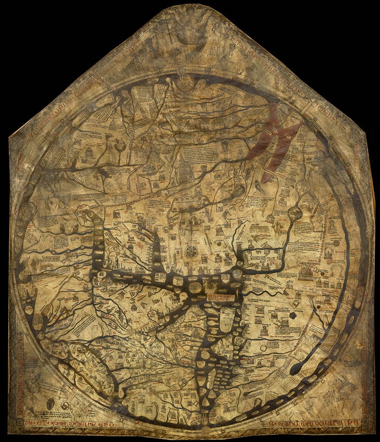
The Hereford Mappa Mundi, circa 1300.
It is preserved at Hereford Cathedral in Hereford, England.
Visitors can peer closely at the 64 x 52 map to search for their favorite locations.
The Hereford Mappa Mundi, circa 1300. (Photo:Wikimedia Commons, Public domain)
Now, online viewers can get this up-close-and-personal experience as well.
Mappae mundi are a genre of medieval world maps.
About1,100are estimated to have survived, mostly within medieval manuscripts.
Others like the Hereford example are large, free sheets of purpose.
The map is drawn in ink on vellum in the style of the medievalT-O cartographic vision.
This schematic divides the world into three quadrants within a circle to represent Asia, Europe, and Africa.
Within the Hereford map, Jerusalem takes center stage.
The map is far from an accurate cartographic record, but it depicts the medieval Christian European worldview.
Paris and Rome are two of the most detailed cities within the European continent.
Asia sits above the T: medieval Christians believe Christ’s second coming would occur here.
Biblical storylines play out across the map.
Exodus, theGarden of Eden, and the Tower of Babel are all depicted withantisemitic characterizationsof figures like Moses.
Mythical people and creatures also populate the Mappa Mundi world.
Viewers can also peer into the mythical Labyrinth or search for the Golden Fleece.
The map’s incredible detail offers endless possibilities.
The public was allowed to view the map at selected times.
Otherwise, it was screened by wooden doors.
Among other treasures, the cathedral holds an ancient chain library and a copy of the medieval Magna Carta.
